![]()
SLOPE SOARING SITES OF SOUTHERN ENGLAND
SLOPES A-B
Here's information on radio control slope soaring sites (model glider flying slopes). This page lists slopes beginning with A and B. Download the pdf from the Home page if you want this information in a prettier format with more photographs.
______________________________________________________________________
BEACHY HEAD, EAST SUSSEX - Winds: SE, E, S
Where’s that then?
On the south coast near Eastbourne.
So what’s it like?
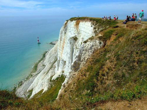
Beachy Head is a pretty remarkable place. It has several slopes as well as miles of cliffs to soar from.
The main slope faces southeast (ESE to be precise) with views over Eastbourne. It is a large grassy bowl set well back from the cliffs, offering excellent smooth lift in east to southeast winds. The bowl is large enough to soar from without having to fly out over the sea. Unfortunately the landing area is a bit tricky. You need eyes in the back of your head to watch out for tourists (when they see a glider landing they often converge on it to get a good look). While dodging tourists you also need to make very sure you do not fly too far back, because vicious turbulence lurks over the sunken road.
There might be a smidgeon of lift here, what do you think?
A few hundred yards to the left of the main bowl is another equally impressive bowl that faces east (known locally as Whitbread Hollow).
To the right of the main bowl there are a couple of small bowls that face SSE.
The cliffs are over 100 metres high - in other words, pretty staggering - and the bowls on top add half as much again. The cliffs are only for experienced flyers since there is potential to lose a plane out to sea. However, usually there is no reason to be near the edge since the bowls are set well back. This is just as well, since these are definitely not cliffs you would want to fall off (those little bunches of fake flowers along the edge mark the locations of suicides).
Sometimes paragliders fly at Beachy Head. Always give paragliders right of way and allow them plenty of airspace. Occasionally the lift fails to appear on hot summer days even though the wind seems perfect. This is due to a strange phenomenon: the warm wind gets cooled by the cold sea and cannot rise up the cliffs. On hot days like this the site would usually be too crowded with day-trippers for comfortable flying anyway.
Beachy Head is public access land managed by the Gilbert Estate. Apparently National Trust rules apply (the BMFA has an agreement with the Trust which stipulates that gliders are allowed but motorised planes are not).
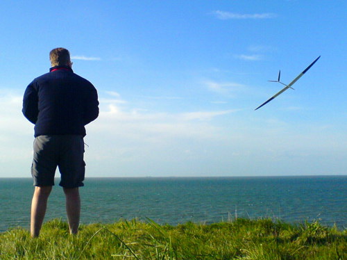
Summer evening flying at the east bowl
Marks out of 10?
Beachy Head gets 7 - and perhaps even 8 when it’s really on. The main flying spot - the ESE bowl - can be superb in the right conditions. However Beachy Head should be avoided during the summer holidays when it gets very crowded with tourists.
How do you get there then?
Drive down the M23 from London and then east along the A27 to the first Eastbourne junction, the A2270 (just to cause confusion this is marked Willingdon rather than Eastbourne). Stay on the A2270 heading into Eastbourne, and a mile before the seafront take a sharp right onto the A259 (this is the coastal road that leads to Brighton). Head west on this for two miles and then take a left onto the B2103 to Beachy Head (it’s well signposted). Park in the Countryside Centre carpark (this is managed by Eastbourne Council and costs £1.40 for two hours - or if you’re feeling cheeky you could try parking for free in the pub carpark).
Another soaring site, Butts Brow, is nearby (you passed it going down the A2270). It also has a southeast slope, although not nearly as good as Beachy Head.
_______________________________________________________________________________
BELTINGE CLIFFS, KENT - Wind: N
Where’s that then?
One of the few coastal soaring sites in north Kent, Beltinge Cliffs rise between Beltinge and Reculver, a couple of miles east of Herne Bay.
So what’s it like?
The cliffs at Beltinge are a rarity in southern England: cliffs that face north. To be precise, some sections face NNW. They work well in north to almost northwest winds. These are irregular, eroding clay banks and cliffs, popular with fossil hunters when the tide is out. The area is public access land owned by the local Council. The landing area is good: quite large and flat. The cliffs are not as high as those at Beachy Head but nevertheless they’re nicely soarable when conditions are right. As with most cliffs, there can be turbulence at the edge. The wind speed range that seems to work best is around 10mph to 20mph. When the wind exceeds about 20mph the lift breaks up into strong turbulence and the cliffs become unsoarable. In winds below about 12mph paragliders sometimes fly at Beltinge.
The cliffs at the Reculver end are a protected area. If you fly along this section you should take great care not to upset the sand martins that nest in the cliffs (obviously this is unlikely, since any glider that collides with the cliff face is about to be lost to sea!)
Marks out of 10:
Beltinge really only merits 5, but the spot is worth knowing about because it is one of the few north facing slopes in Kent. One other is at Minster on the Isle of Sheppey (see the Minster Cliffs section). Beltinge offers slightly higher cliffs and a larger landing area than Minster.
Just don't get too near the edge ...
How do you get there then?
Drive from London eastwards on the M2 and take the A299 towards Herne Bay. Go a couple of miles along the coast to the village of Beltinge. The cliffs run for about a mile between Beltinge and Reculver. Park in the carpark at the end of Bishopstone Lane. You can launch from the grass area in front of the carpark.
We’re talking about 70 miles from the east side of London, so Beltinge is one of the furthest sites that are within relatively easy shooting distance of the capital. Perhaps you could convince the kids you’re taking them on a fossil hunting adventure ...
_______________________________________________________________________________
BOPEEP HILL, EAST SUSSEX - Wind: NE
Where’s that then?
Near the south coast, just south of the A27 between Brighton and Eastbourne.
So what’s it like?
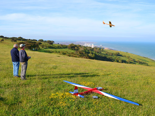
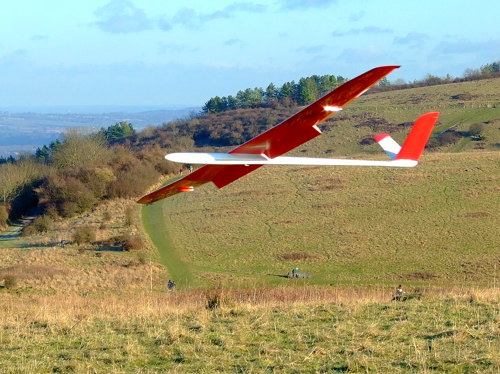
Nice. It’s a civilised sort of hill, but quite steep, so there’s good lift. The landing zone is large and free of hazards. The slope faces northeast and - surprise, surprise - flies best in northeast winds. In fact there are three slopes here, all equally good.
There is lots of lift over the launch area so planes need to be thrown forwards, not even slightly upwards
In many ways the slopes at Bopeep are like Firle, and indeed Bopeep Hill is less than two miles from Firle. Bopeep’s air is sometimes not quite as smooth as Firle’s, but Bopeep seldom gets crowded, whereas Firle can be pretty popular at weekends.
Sometimes Bopeep hosts paraglider schools on the slope nearest the carpark. This is usually when the wind is less than 10mph or so. If this happens, you can either walk 600 yards further east, or head in the opposite direction by crossing the road and walking 500 yards west. The slope to the east is perhaps fractionally better than the other two. Should any paragliders enter the model glider aerial fray, always give them right of way and fly away from them. Further advice on this issue can be read here: BHPA Policy.
There is lift over the landing zone of all slopes, so getting your plane down can require determination. The good news is that there is very little turbulence behind the landing areas, so you can safely fly well back and land slowly.
The site is called Bopeep because you access it by going up Bopeep Lane and it is opposite Bopeep Farm. However the hill is actually called Bostal Hill - not many people know that. The farm is a Bed & Breakfast (bopeepfarmhouse.co.uk), so you could stay here and just walk half a mile up the hill to fly (bet you drive, though!)
Marks out of 10?
What do you reckon, 7? You might even say 8 when you consider that there are several good slopes.
The slope 600 yards east of the carpark is possibly the best slope of all - if you can cope with the walk
How do you get there then?
Get yourself down the M23 to the A27 and head east. About six miles past Lewes, watch carefully for the small lane on your right called Bopeep Lane. It's just after the village of Selmeston. Drive a mile up Bopeep Lane and park in the carpark on the left. If you fancy a challenge it is possible to cross-country soar westwards all the way to Firle and even onwards to Itford Hill.
Bopeep Hill is public access land. Apparently National Trust rules apply (the BMFA has an agreement with the Trust which allows unpowered glider flying but prohibits powered models - if you have an electric powered glider you can simply tape the blades to the fuselage).
____________________________________________________________________________
BOX HILL, SURREY - Winds: S, W
Where’s that then?
A handful of miles south of the M25 near Dorking.
So what’s it like?
Box Hill is a country park owned by the National Trust. It has a pay carpark and take-away cafe at the peak. There are several flyable slopes but they can only really be used at times when there are few people about.
The main slope is a couple of hundred yards from the cafe. It is a medium-sized slope that faces south to SSW. It has a stone lookout point at the top which is popular with day-trippers. The slope is moderately steep with a rounded top so the lift can be quite good.
The landing area could be better: you have to land on the slope, or possibly fly your plane over the road behind the slope and land in the field there. The difficulty is that on pleasant days there are lots of walkers and picnickers occupying the area. So this slope is best flown on cool, cloudy days when it can be surprisingly deserted. If the slope is occupied, try walking down to the bottom of the landing area: if you go through the row of bushes a whole new lower slope is revealed. This area benefits from being wider - it extends for several hundred yards further westwards - plus it is less likely to have people on it. So this lower area can be the smartest spot for launching and landing.
The main slope: sometimes crowded, sometimes deserted
Half a mile away is a west slope overlooking the A24. It is a shallow grassy slope about 70 metres high. It works for WNW to WSW winds. It tends to have fewer walkers on it than the main slope does. There are views over Denbies winery (don’t even think about abandoning the soaring for a wine tasting session!) The lift is pretty meagre. However, rising thermal air currents often add lift: all those cars racing along the A24 seem to generate enough heat to spawn good thermals. Box Hill's west slope may not be the greatest slope but it is the only west facing slope for many miles.
When flying on the west slope you can just see another slope in the distance next to the vineyards: Denbies Hill. This is not the greatest slope in the world either, but it definitely has its good days and is worth knowing about in case Box Hill is too crowded. The slope is over 100 metres high. The ideal wind direction is south. If you go through the gate at the bottom of the landing area and head right for a couple of hundred yards you’ll find another pretty little slope that often seems to have superior lift. What a view!
If none of these slopes are lighting your fire, consider heading over to Colley Hill, which will have more lift. It’s about a 15 minute drive.
Marks out of 10?
Box Hill’s main slope scores 5. So does Denbies Hill. The west slope at Box Hill is probably only a 3!
How do you get there then?
You can reach Box Hill’s slopes from either end of Zig Zag Road. The main way in is from the A217: drive down the A217 from central London, past Sutton, then at the large Kingswood roundabout (which is a couple of miles inside the M25), go slightly to your right down the B2032, Dorking Road. Go over the M25 (gazing down smugly at the poor fools in the traffic jams) and follow the signs to Box Hill (which involves taking a brief right onto the B2033 and then left onto Box Hill Road). After a couple of miles this becomes Zig Zag Road and you will see the slope on your left. Actually to be precise the slope goes down out of sight and what you can see is the stone lookout point. If you reach the National Trust Cafe you’ve gone a couple of hundred yards too far. Buy a piece of cake to recover from the shock and then get back to the slope.
The west slope is half a mile away at the far end of Zig Zag Road. Park in the little carpark on the right just after the last hairpin bend before the park exit (now you know why it’s called Zig Zag Road). Cross the road and climb about 50 yards up some steep little wooden steps to the peak. The slope is on the other side, overlooking the A24.
The lift at Denbies' lower slope can be surprisingly decent - but trying to land on the slope can be a bit indecent!
![]()
To get to Denbies Hill from the west slope, exit the park and turn left past the biker cafe onto the A24. After about half a mile take a right into Ashcombe Road (signposted Guildford). Continue straight as it becomes Ranmore Road, following the signs towards Ranmore. After maybe a mile and a half park in the National Trust carpark on the left. It’s signposted Denbies Hillside.
As at many National Trust sites these days, you are supposed to pay £2 to park if you’re not a National Trust member.
The National Trust has a policy of encouraging glider flying, but occasionally wardens may be unclear on this point. Here is the official National Trust wording on the matter (available on its website):
"The National Trust welcomes non-powered model flying on its land, recognising that the activity seldom causes significant disturbance, provided particular care is taken with regard to other visitors, livestock and birds."
____________________________________________________________________________
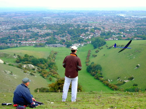
BUTSER HILL, HAMPSHIRE - Winds: NE, W, N, SW, E
Where’s that then?
Down the A3 ... way down towards Portsmouth.
So what’s it like?
Butser Hill is one of Hampshire’s main flying sites. It is a large, exposed hill with slopes facing a variety of directions. The northeast slope is perhaps the best one - it provides good lift and easy landing on the flat hilltop. It offers wonderful views over the surrounding countryside. It works best in north to northeast winds - if the wind is any more easterly the lift quickly becomes erratic because there is a hill jutting out on the right that blocks the wind. The west slope is also a very good slope as long as the wind is directly west (it is a pronounced valley pointing west so smooth air from any other direction cannot reach the slope).
The southwest slope is a bowl and is turbulent except in low winds, so it’s not for beginners. The north slope provides reasonably good lift but landing can be tricky since there is lots of lift and turbulence in the landing area. The east slope also provides quite good lift but the launch is challenging since you have to hurl your plane over a fence and trees. The treetops bear skeletons of unreachable planes!
The slopes radiate from the large, flat hilltop, so access is unproblematic. Each slope involves a walk of 5 to 10 minutes from the carpark.
A model soaring club operates from the site (see mvsa.co.uk). Membership is not mandatory, but is well worthwhile if you live in the area. The club operates a frequency pegboard at the site. Unlike some sites, electric powered gliders are allowed at Butser Hill.
Butser Hill has a good variety of slopes
The club also operates a site a few miles east at Harting Down which is truly excellent in north to northwest winds. The slope is steep and mainly faces NNW. The lift can be strong yet quite smooth. The landing area is large and flat. So it’s all good!
BMFA insurance is required to fly at Harting Down. If using a 35MHz transmitter, only even frequency numbers should be used (for example channel 64 but not 65). If you meet any club members there, be nice, because they have rights to the site under an agreement with the National Trust.
Marks out of 10?
Each slope individually is in the 4 to 6 range, but put them all together in one place and Butser Hill is worth 7 out of 10.
How do you get there then?
Drive down the A3, past Petersfield, and the hill is on your right – keep an eye out for the telecommunications mast on top. Wave at it as you pass because there is no exit here. Almost a mile further on, take the exit on your left marked Butser Hill, keep heading to your left to go back over the A3, turn right at the mini roundabout towards London and then follow the Butser Hill signs up Hogs Lodge Lane to the carpark at the top of the hill. You have to pay £1 at the entry barrier to park as long as you like. Butser Hill is part of Queen Elizabeth Country Park (the land is owned by the Council) and the park’s postcode is PO8 0QE.
Harting Down: nice lift and nice landing
Harting Down is about 5 miles east of Butser Hill, on the B2141, a mile or so south of the village of South Harting. There is a National Trust carpark at the top of the hill on the left. It costs £2 to park (free for National Trust members). The slope is about 400 yards east of the carpark along the ridge.
The club also has access to a couple of other slopes on private land (such as the east-facing HMS Mercury site on Wether Down, two miles west of Buster Hill) so it’s worth joining the club if you live in the area.
Butser Hill Map
Harting Down Map
_____________________________________________________________________________
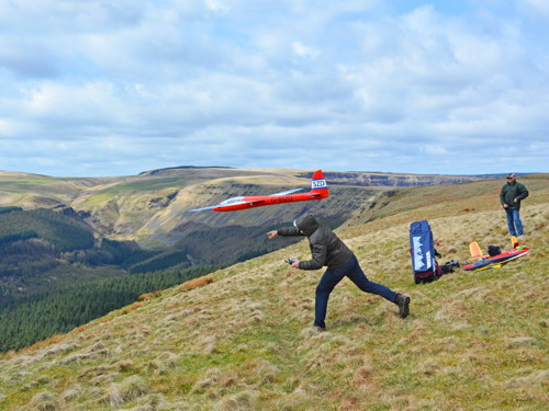
BUTTS BROW, EAST SUSSEX - Winds: E, N, SE
Where’s that then?
In Willingdon, a village on the outskirts of Eastbourne, on the south coast in East Sussex.
So what’s it like?
This hilltop reserve has several slopes. The two best slopes are the east and north bowls. The east bowl is a large slope, moderately steep, about 100 metres high. It produces good lift in northeast to east winds. The perfect wind direction is east or ENE, but you can amble around the rim to the right to fly in northeast winds. The landing area is reasonable. There is a fence along the top to avoid. Take care not to knock over any walkers when landing - it doesn't go down well. There are also a few trees just down the slope that can catch you out. You might think you’ve caught your plane in a bush six feet high, but when you walk down you realise your pride and joy is actually thirty feet up a tree!
The area also has a good north slope nearby (a couple of hundred yards further from the carpark). This is also a large bowl, with reliable lift and an excellent flat landing area. It works best in north to NNE winds. Some say it is even better than the east bowl because it has a larger landing area and fewer trees to catch you out.
The east bowl provides good lift
There is a less exciting but quite pleasant southeast slope a few hundred yards to the south. This slope overlooks a golf course and the sea beyond. It is a gentle, medium-sized slope and offers fair lift, low turbulence and reasonably good landing possibilities.
Butts Brow is generally a fairly quiet flying area. It becomes more lively on days when the good folks of the East Sussex Soaring Association get together to fly there. The club occasionally holds friendly competitions at Butts Brow and Long Man Hill, varying from relaxed fun flies to aerobatics contests to national races. If you fly in the area the club is well worth joining: eastsussexsa.co.uk
Marks out of 10?
This one is distinctly 7.
A hefty launch
How do you get there then?
From London, head down to the south coast on the M23. Go east along the A27 past Lewes. Go down the first road into Eastbourne (the A2270, Eastbourne Road - confusingly this is signposted Willingdon rather than Eastbourne). After about two miles head slight right down the small road signposted Willingdon Village. In the centre of the village turn right into Butts Lane. Haul your butt up the lane’s steep incline, which takes you to a public reserve (owned by the local council) which rejoices in the rather unlikely name of Butts Brow. Park in the first carpark on the right. There is a charge of £1.40 for two hours parking and you need to have the correct change: beware, the wardens can be ruthless.
The east bowl is about 300 yards north of the carpark (away from the radio mast that is visible from the carpark). The north bowl is about 200 yards beyond that. The southeast slope is the other way, about 200 yards south of the carpark (past the radio mast).
_____________________________________________________________________________
BWLCH AND WALES - Winds: NE, E, SW, W, S, N, NW
Where’s that then?
The Bwlch is in south Wales, on
the A4061, four miles from the town of Treorchy.
So what’s it like?
England has hills, but Wales has mountains. That is why Welsh slopes merit special guest status in this guide despite the fact that they are not in England.
The Bwlch is an area of huge slopes around a winding alpine-style road in the mountainous region of central south Wales that includes the Brecon Beacons. The area has almost endless potentially flyable slopes, but many are difficult to reach because the only roads are down in the valleys. So hard hiking can be required.
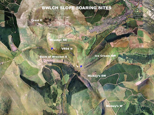
Click on the map for a large version of it (or go to www.slopehunter.com/bwlch.pdf)
The Bwlch slopes are perhaps twice as high as England's major slopes, and twice as steep as well. This gives them a certain infamy because the lift is huge but challenging. Flying at the Bwlch can involve arduous hikes, severe weather, high winds, extreme speeds ... and wrecked gliders. There is a reason the slopes have been given names such as 'Wrecker'! Bwlch air is seldom smooth because most of the Bwlch's slopes face other slopes across the valleys. The wind is often far stronger than on the flat, so about the only time the Bwlch might be considered relaxing is when the forecast is only 5mph or so.
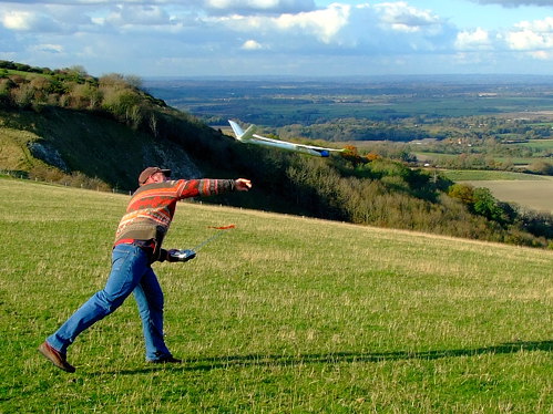
In the milder months Mickey's is one of the most flown slopes because the prevailing winds are southwest to west. Mickey's has a southwest section (starting a few hundred yards from the layby marked by the lower of the two blue 'P' signs on the map), and about a mile further on, a west section. Both sections of Mickey's are slightly milder slopes than Wrecker, and have nice large grassy landing areas. However the hike is quite difficult.
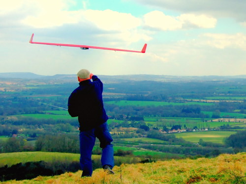
A firm launch into big wind at Mickey's slope
The layby often has an ice cream van parked in it, which is why the other nearby slope is known as the Ice Cream Slope. It is a grassy slope facing northwest. It also involves a bit of a hike.
In northerlies the stunning 'mega-bowls' come into play: Wrecker and Crest. Wrecker - the most famous of the Bwlch slopes - works in northeast winds. Crest works in east winds. Wrecker is right by the road (alarmingly so, in fact: take great care not to fall off the edge). Park in the layby on the A4107 shown by the upper of the two blue 'P' signs on the map. The best flying spot is probably about 150 yards to the left of the layby - or whichever section of the bowl is facing most directly into the wind. It is possible to fly from the layby if you are concerned about getting too close to the edge. The right end of the Wrecker bowl is sometimes known as VR98 (after a competition that was held there in 1998) and faces north. Crest - the biggest bowl of all - is a longer walk from the same layby. The Back of Wrecker is also a large, steep slope. It faces south and is also reached from the same layby. Further information on the Bwlch can be found at www.knewt.com. (By the way, English speakers pronounce 'Bwlch' halfway between 'Bulk' and 'Book' - although the true pronunciation ends with a Welsh guttural 'ch' sound which is hard to say in English.)

This is the view from the top of Wrecker, a few feet from the parking lay-by
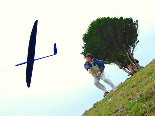
Wales has many other large slopes apart from the Bwlch. About an hour’s drive from the Bwlch is a specialist slope soaring spot called the Skirrid. This is a razor ridge - an unusual hill shape for Britain. It runs north-south and so works in west and east winds. The sharpness of the Skirrid ridge and steepness of its sides make it excellent for Dynamic Soaring (flying in circles on the 'wrong' side of the ridge to achieve high speeds). The top of the Skirrid is rocky and there is no landing area, so this is not a spot for beginners. The climb up from the carpark is difficult and takes the best part of an hour. The carpark is at the southern end of the ridge (a National Trust layby on the B4521).
Wales has many coastal flying sites and perhaps the two best known are the Great Orme and Rhossili. Both are giant-sized coastal slopes. The Great Orme is in the north of Wales and Rhossili in the south. The Great Orme is a bit of a monster, and in fact it must have given this impression through the ages because Orme is a Viking word for a sea monster. The Great Orme is next to the seaside town of Llandudno. It works in a variety of wind directions. A friendly group of slope soarers fly there, and helpful advice can be found by Googling 'Stormeflyers'. Rhossili is a touristy village in the picturesque Gower Pensinsula area. It is surrounded by many flyable cliffs facing various directions. The largest flying spot is the huge sloping ridge overlooking Rhossili Bay. It faces west. The main parking area is at the far end of the village (£3) and then it is a case of walking through the village and hiking up the rather arduous hill. Some of the local flyers part behind the ridge by driving up a small road called Bunker's Hill, but it is a slightly longer walk (although less steep).
Rhossili Bay’s ridge runs for about three miles and is flyable all along its length. It produces wonderful, smooth coastal lift, and is free of turbulence because there is no vertical cliff or sudden lip. The landing area is very good: it is flat and covered in low gorse which cushions the impact. In low winds paragliders use the end of the ridge nearest the village so it is best to walk further along. It is also possible to access the far end of Rhossili Bay from the village of Llangennith.
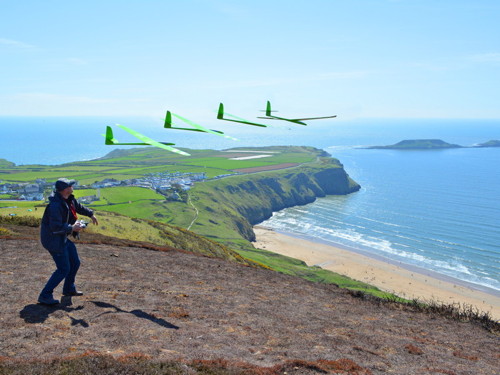
Launching at Rhossili Bay
More Welsh slope soaring sites can be seen on the Slopehunter Google Map.
Marks out of 10?
The Bwlch is awarded 8. If you are a bit of an adrenaline junkie you might even call it 9 ... but if you hate hikes and drama you will probably rate it lower.
How do you get there then?
The Bwlch is on the A4061, four miles south of Treherbert/Treorchy (two villages that have fused into one town). From the Bwlch the A4061 continues down to junction 36 of the M4 motorway.
The Skirrid is on the B4521 near Abergavenny. From Abergavenny go up the A465, turn right into the B4521, and park in the National Trust layby. Abergavenny is accessed by driving north from junction 26 of the M4.
The Great Orme is next to Llandudno in north Wales. It is 60 miles west of Liverpool taking the A55. It is 150 miles north of the Bwlch (which could take four hours!)
Rhosilli is 18 miles west of Swansea on the Gower Peninsula. From Swansea take the A4118 (Gower Road). Swansea is on junction 44 of the M4.
_____________________________________________________________________________